
 44.0°,
Mostly Cloudy
44.0°,
Mostly Cloudy Army Corps to search for solutions to coastal flooding in back bays study
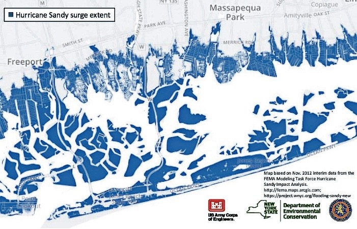

Hurricane Sandy proved, beyond a reasonable doubt, what many experts had long predicted: Long Island’s South Shore could flood in a big storm. But what of the future? Could it flood again? How badly? To answer such questions, the U.S. Army Corps of Engineers has partnered with the state Department of Environmental Conservation and Nassau County to conduct a risk management study of the South Shore’s back bays.
“[We] are excited that the U.S. Army Corps of Engineers is joining several other agencies in studying ways to anticipate and mitigate the potential damage future storms and rising sea levels may cause the citizens of the South Shore of Long Island,” said East Rockaway Mayor Bruno Romano. “The village has been meeting regularly with state agencies looking into flood solutions, and [is] thankful to have the federal government also participating in this vital study.”
After Hurricane Sandy, the Army Corps completed the North Atlantic Coast Comprehensive Study, which named nine high-risk areas on the Atlantic Coast. The Nassau back bays — Hewlett Bay, Middle Bay, Jones Bay, South Oyster Bay and associated creeks, channels and minor water bodies — were identified as a high-risk region that warranted an in-depth investigation, according to County Executive Ed Mangano.
The New York District’s Army Corps’ recently hosted two community meetings, called “scoping sessions,” in which it invited residents to voice their concerns. They took place on May 2, at Seaford High School, and on May 3, at Freeport Village Hall.
At the first meeting, Clifford Jones, chief of the New York District’s planning division, explained that the South Shore faces an increased risk of natural hazards caused by coastal storms, including powerful waves, storm surges, floods, severe winds and erosion. He added that many densely developed areas of Nassau County are at low elevation, and flood not only in storms, but during high tides.
State Sen. Todd Kaminsky, a Democrat from Long Beach, wrote a letter to the Army Corps on May 8, requesting that officials hold scoping sessions in Long Beach or the Five Towns. He noted that residents of those communities, as well as Oceanside and Island Park, would have had to travel more than 40 miles to get to and from the Freeport or Seaford meeting.
“Freeport and Seaford are a mere six miles apart, which means those hearings are accessible by largely the same people,” Kaminsky wrote. “Further, little was done in … other affected areas to advertise these hearings, and many people were not aware of them. Adequately promoting future hearings and providing sufficient notice will expand the number of people who attend and receive this vital information.”
Jones said that the Army Corps planned to schedule public meetings at other locations as the study progresses.
The three-year study was launched last September, with the goal of recommending a plan to Congress for coastal storm risk management for communities along the bay shorelines, according to Danielle Tommaso, a project planner.
Tommaso said that the purpose of the study is to develop a nine-step plan to reduce flood risk. In the first phase of the study, which Jones said is expected to last through the summer, officials are inviting local analysis — including resident commentary — of current conditions, so the most vulnerable areas are identified. After that, Tommaso said, officials will evaluate and compare potential solutions to finalize a plan.
“The study is at its infancy,” she said. “We need community involvement to create a synergistic path for moving forward.”
Jim Ruocco, a Freeport resident, attended the Seaford scoping meeting. Ruocco, who volunteers for Operation SPLASH, a nonprofit committed to improving the quality of life on Long Island’s shores, recommended a holistic approach to flood mitigation for the South Shore. “Building a system of dikes, levees and movable floodwalls would account for anticipated sea level rise and provide protection against the 500-year storm,” he said. “Hardening, street elevations and home raising could never be accomplished with hundreds of billions in funding and with rising tides and climate change. Those solutions would not even serve as a long-term cure.”
Army Corps officials predict that sea levels will rise by 5 percent by the year 2100.
Protective measures being considered in the study are described as structural, non-structural, nature and natural-based. Structural measures include infrastructure such as seawalls, levees and storm surge barriers. Non-structural measures include elevation of homes and buildings, flood-proofing, relocation, flood warnings and insurance, land-use management and zoning changes.
Natural and nature-based measures are “green infrastructure,” according to Tommaso. They includes beach and reef restoration, “living” shorelines (using plants, sand and rock to protect shoreline and maintain valuable habitats), wetland conservation, growing plants in shallow water and drainage improvements.
All potential solutions will be evaluated for their economic and technical feasibility and environmental acceptability through detailed engineering and environmental analysis as well as ongoing public input, Tommaso said.
The Army Corps will draft a plan for coastal storm risk management, for approval by its headquarters, likely by next spring. Jones said that once it is approved, it will be sent to Congress for authorization in 2019.


