
 67.0°,
Overcast
67.0°,
Overcast Bellmore, Merrick slammed by coastal flooding
How the community awoke to a messy commute this morning


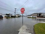

Bellmore and Merrick awoke to a messy scene Friday morning.
An overnight rainstorm that brought the hamlets high winds and heavy rainfall, coupled by high tide beginning around 8:40 a.m., led to flooding in neighborhoods near the coast.
Those living south of Merrick Road in Bellmore shared on community Facebook pages that the morning drop off at John F. Kennedy High School and Shore Road Elementary School was significantly complicated by the weather.
Residents living directly on the water shared photos and videos with the Herald of the canals seeping into their yards. Streets such as Sunrise Avenue, Legion Street, Shore Road,and South Centre Avenue, among several others, were affected.
In response to the damange, North Shore Auto Body of Oceanside, Lynbrook and Bellmore helped those affected by the storm.
"All of our employees are currently out recovering flood and tree damanged vehicles," a Facebook post stated. "If this has impacted your vehicle, call any of our four locations. If anyone is in need of help, even if it's not car related, don't hesitate to call us."
County Executive Bruce Blakeman and the Department of Public Works updated residents on what they can expect in the aftermath of the storm, and how to safe.
“I'm happy to report that we are through the first storm and that things are getting back to normal,” Blakeman said inside the Office of Emergency Management in Bethpage. “But that will be short lived.”
Blakeman said that most of the rainfall occurred around 7:30 a.m. — around the same time as high tide — which caused most of the coastal flooding throughout the South Shore of the County.
“We now have the flooding under control,” Blakeman said. “Our DPW is out, they are cleaning drains, they've pumped out water and our DPW will start preparing for the second storm that will be arriving this afternoon.”
The second storm will feature a cold snap, with a “30 degree downward swing,” according to Blakeman, with the wind chill feeling as low as negative five degrees.
“With that there will be a significant amount of ice on the roads, even though we're out salting, and it will be a dangerous condition,” he said. “We're asking everybody to please stay home or stay local. Do not go out on the roads unless you have to. Tomorrow will be a much better day to go shopping.”
County Police Commissioner Patrick Ryder said that there was around 32 car accidents last night, which is normal amount for a storm like this. There were 104 calls for people trapped in their car due to flooding. One house in East Rockaway was evacuated, but nobody has been injured or have died.
The County Exec. said that he expects road conditions to be decent by 10 or 11 a.m. tomorrow.
The high wind speeds caused some power outages and downed trees as well. Around 2,000 county residents are experiencing outages, and there could be with the anticipated high wind gusts this evening. Blakeman said that they are in touch with PSEG, who are working on the current outages and are prepare for more.
For anyone who is experiencing a loss of power and heat, there are warming centers set up at from 8 a.m. to 6 p.m. for the next 48 hours at Wantagh Park, located at 1 King Rd., in Wantagh and Cantiague Park at 480 West John St. in Hicksville. There will be a 24 hour warming center at Mitchel Field in Uniondale.
Blakeman advised residents to keep pets in doors due to the cold weather, and to check on any elderly neighbors who may have lost power. He said to stock up on fresh water and bottled water and keep a flashlight ready. If you want to burn candles, make sure they are fully out before going to bed.
“Our trucks are already out salting, preparing the roads, and we are hopeful that we'll get the ice under control but there will be patches of ice that you will not be able to see,” Blakeman said. “Please exercise extreme caution. Keep your speed down and stay alert.”
More to follow. Additional reporting by Mallory Wilson. Have videos or photos? Email jvallone@liherald.com.


